
 EN
 IT
 ES
 FR
 ZH
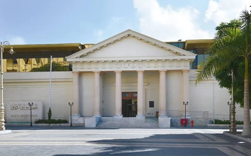
The Graeco-Roman Museum in Alexandria: Discovering Egypt's Hellenistic Heritage
During 331 BCE, Alexander the Great chose a strip of land along the Mediterranean coastline to set up his new capital named after himself, Alexandria. This city was very carefully planned as a classic city however, its huge wealth, navy and global trade all relied on the natural geographical features of the area. These features included the natural limestone island of Pharos and the twin harbours built around it. Over a thousand years later, the island was used as a natural breakwater and was used as the base for the famous Alexandria Lighthouse. The ancient harbours of Alexandria would be used to trade goods around the world. By looking at the geographical features of the area, the Heptastadion bridge, the Great Harbour and the Eunostos Harbour we can understand how remarkable these ancient harbours were.
1. Geography and the Genius of Alexander
By observing the geographical features of the north Egyptian coastline we can understand the genius behind Alexander’s port.
A. The Flat Coastline
The Nile Delta coastline of the Mediterranean was very flat and dangerous for ancient sailors. Hidden sand bars, changing currents and stormy seas meant navigating to the Egyptian coast was difficult. Alexander the Great and his architects realised that to create a great port they needed a large, deep section of sea that would be protected from the rough sea.
B. The Natural Breakwater
Off the coast of the small native Egyptian village of Rhakotis was the long, thin limestone island of Pharos. This was located just over a mile away from the main land and formed a natural barrier against the strong northern winds and waves. With the island secured a natural sheltered area was created. Between Pharos and the mainland there was a body of water which became a secure deep area of water to moor hundreds of ships.
2. The Heptastadion Bridge
With the natural protection of Pharos the Heptastadion Bridge transformed the open stretch of water into two efficient world class harbours.
A. The Causeway
Alexander’s leading architect Dinocrates of Rhodes made a large artificial causeway linking the island and the mainland. This was called the Heptastadion, the name coming from the size of it being seven stadia long (1,200m / Three quarters of a mile). This was large enough to allow people to walk along but also horses and carts carrying supplies and soldiers.
B. Twin Harbours
The open area of water was split into two large harbours by the Heptastadion Bridge.
The Great Harbour (Portus Magnus) – This was located on the eastern side of the bridge. This was the centre of the port for the Royal family and military of Alexandria. The harbour was positioned right under the magnificent marble palaces of the Brucheion district. Here were moored the Egyptian war fleet, state barges and official ships.
The Eunostos Harbour (Harbour of Happy Return) – This was located on the western side of the bridge. This was used solely for international trade. Merchant ships and fishing boats would dock here.
Two arched bridges were placed along the Heptastadion Bridge. These were held up by huge wooden sluice gates allowing water to be let in and out.
3. The Pharos Lighthouse
The Pharos Lighthouse was situated at the furthest point of Pharos island. Due to this feature the island became world famous!
A. Navigation
This was built during the third century BCE by Ptolemy I Soter and Ptolemy II Philadelphus. It was designed by the famous Greek engineer Sostratos of Cnidus. The three tiered lighthouse was over 100 metres tall. The lighthouse’s main use was to guide merchant ships past the dangerous limestone rocks surrounding the island and show them where the narrow channel into the Great Harbour was.
B. Day and Night
The top part of the lighthouse had a huge fire burning creating a bright beam of light visible for many miles. During the day the keepers would use a highly polished mirror to reflect the sun’s rays across the sea. The lighthouse was used throughout the Ptolemaic, Roman and Byzantine ages lasting almost sixteen centuries. However it was destroyed by a series of terrible earthquakes in the 14 th Century.
4. The Ancient Harbours
During the reign of the Ptolemaic Kings and Roman Emperors the ancient harbours of Alexandria were the busiest trading centres in the Mediterranean.
A. Grain Trade
After Egypt was annexed by the Romans in 30 BCE the ports became extremely important. They were the central place for the annona. This was the huge amount of grain sent every year to feed Rome. Hundreds of grain freighters would load thousands of tonnes of grain from the Nile Valley during the Spring and Summer. These would then sail across the open sea to Ostia and Puteoli.
B. Red Sea and Mediterranean Trade
The harbours were linked to the river systems inland. Canals were built linking the Eunostos Harbour directly to the Lake Mareotis and Canopic branch of the Nile River. Rare silks, spices, frankincense, ivory and gemstones would be imported from the ports of Berenike and Myos hormos on the Red Sea. These items would be unloaded onto the lake quays and loaded back onto merchant galleys for transport to Greece, Italy and Spain.
5. Underwater Archaeology
During late antiquity and the medieval ages many terrible earthquakes occurred causing the coastline of ancient Alexandria, including the Heptastadion and Royal areas of the Great Harbour to sink into the sea.
A. Underwater Excavation
During the last few decades ground breaking underwater archaeology has been carried out by Franck Goddio and Jean-Yves Empereur. Using powerful sonar equipment, nuclear magnetometer and divers archaeologists have mapped out the fully submerged coastline of the Eastern Harbour.
B. Discoveries
Divers have found thousands of artefacts underwater.
Monumental statues of Ptolemaic Kings and Queens carved like classic Egyptian Pharaohs and Sphinx.
Huge blocks of stone, door arches and column sections from the fallen Pharos Lighthouse.
Ancient shipwrecks; stone anchors and amphoras have been found. This provides clear evidence of how busy the ancient harbours were.
Conclusion
Pharos Island and the ancient harbours of Alexandria are some of the greatest examples of ancient maritime engineering, city planning and organisation. By creating a twin harbour system using the natural limestone land and open sea they built a bustling port that helped to run the Ptolemaic Kingdom and Roman Empire. Although the ancient coastline is now under the blue waters of the Mediterranean, Pharos Island remains a world famous landmark showing how important it was as a trading centre, navigational aid and example of mankind’s ingenuity.